Visual Asset Strategic Tools. Capture Building Information for Building Life Management. Open Source/Low Cost Technology Solutions for you to control your buildings
I have been looking at some of the free Data Science and Cognitive Computing Courses and was following the Data Journalism: First Steps, Skills and Tools course. The Google Searching video was on improving your searches in Google using the following: quotes to get specific key words eg “data science on construction” using – sign
There is an interactive tutorial here running Python. This instance is running from another website so could be slow. I found this video extremely good for setting up (I used the pip install method not anaconda) and how to use it. The Jupyter Notebook The Jupyter Notebook is an open-source web application that allows you
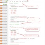
I have downloaded a lot of stuff from Github but haven’t really bothered figuring what it was about. I found this video a simple way to get my head around it and get to use it initially: Github Tutorial For Beginners – Github Basics for Mac or Windows & Source Control Basics I had signed
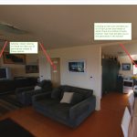
Panoramic files (360/180) can be viewed directly with a programme such as Paint, but they do not make much sense. You need a specific Panoramic programme to read the files correctly. I use the FREE photo sphere viewer by Jeremy Heleine. Follow the link to see the demos. The method that the programme uses is
The new photo sphere viewer by Jeremy Heleine allows you to put Markers on your Panorama . See demo here. I think that is pretty cool and I wondered if you could make them into Hyperlinks to link other panoramas to make a virtual tour. So I did some tests. My previous way to be
I was looking at doing a project to test web scraping with Python. I came across this article from AIA about how many architects does the economy in the US need in the future. I found that a lot of the data used was from general government sources. So I thought I would look at
After trying and writing post about EpiCollect5 I decided to look at another data collection tool, Open Data Kit (ODK). A brief overview of it in video below: This has some strengths and weaknesses over EpiCollect5. Weaknesses: Only Android App, not Apple (but since there are lots of cheap Android mobiles this is not a
I had a couple of attempts at creating a mobile phone app for surveys. See this post and this one. I got distracted by the CRUD process and let it rest for a while. Whilst looking for some Python Mapping tools, I came across this article regarding capturing GPS data and was taken with the
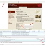
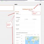
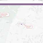
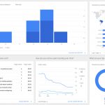
This is the LINK to the report. The idea is to use powerBI to display data about different elements on a Dashboard so you can drill into the data. In the above screenshot I have tables showing Standard, Upper & Lower Baselife Data with conditions by colour and a map referencing where the properties are
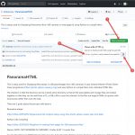
Google needs to know your web pages to see your site. So when people type in a search your site and its pages need to be indexed so that they can be found. Inside WordPress you need to add a plugin that maps your site pages and posts. The plugin I use is Google XML