QGis Madeira Basic conns to Maps/.csv’s/Databases
I thought I’d have a look at QGis again now that it has been updated.
I’m always wow’d by what people can do with the GIS mapping. Unfortunately for me I’m an amateur playing in this area. I did a cartography course at Uni way back and enjoy exploring some mapping tools.
As QGis and other mapping programmes are not my everyday tools, a bit like GIMP the raster graphics editor used for image retouching and editing tool, I struggle to become familiar and comfortable with the programmes and productive with them.
That does not stop me being interested and trying to learn a bit more about them. Becoming a little familiar with them and their capabilities allow me to think of using them as a possible tool in the future.
I have been YouTubing some of its newer features and came across a few interesting things.
A basic tutorial on creating a map:
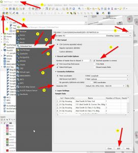
Printable Map (to PDF)
What I quite liked about the video above is he creates a printable map at the end. I tried doing that too, and found, if you zoomed out too far it took ages for the map to render, only when in was down at block scale did I find that it rendered the map in a reasonable time.
BACKGROUND Google, Bing, OSM and other maps
Another couple of videos show how to bring in underlay maps such as Google, Open Street Map & Bing using the XYZ Connection.
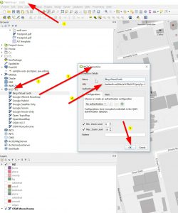
With his link to his website for URL strings HERE.
Also, there is this video that has other OSM and Bing ones too:
Linking to Datasets (spreadsheets) & Databases
My databases are normal tables, I have generally uses MySQL, MS SQL & PostGres. I know that Postgres has a GIS add in for Spatial Data ( I was trying to add GIS data into OpenMaint). There is also a link for connections to a MS SQL database, although I was not aware that they had any special spacial tables, but found this link to a page on it here.
Spreadsheet import
I have a couple of QGis maps with data from Excel files, imported as .CSV files. I have just been re-importing some of that data in as a CSV file.
I saw a pre- V3 QGis video on uploading from a Spreadsheet here, where the presented created a .CSV and a .CSVT file (this managed file column types as it imported all columns in as type “strings” so coulddn’t read the Lat/Long columns as it saw it as text, not numbers.
I just tried the process with a CSV file and as long as you bring it in as a CSV it formats column types (String, integer, etc) correctly, so no need of the 2nd file .csvt.
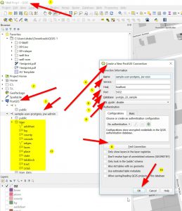
Database- Postgres
At this point I just wanted to link to a database. I would have preferred to be able to link to data but have not got tables set up for it. I’m just pleased to be able to connect to the DB (I have had major issues with other programmes such as Knime with connecting to DB’s) .
Selecting PostGIS you can select a Postgres DB with a GIS addin. (I’d done this previously and will have to refer back to my OpenMaint posts to see how I added this in). The actual tables highlighted in yellow are GIS tables but are all empty.
The “SERVICE” input box flumoxed me, but leaving it empty works. Testing the connection works too. On my PostGres Database I had to have a login and these were used here.
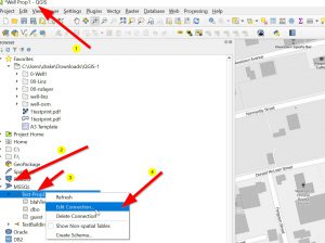
MS SQL login to Database
I’m not sure about specific tables that meet the spacial Data requirements for this database, but I got the connection to the database working, but no tables as I have no spacial Data tables. I’d need to do some research on these.
Leaving the Provider/DSN input box seems to work as when I checked List Databases all the databases showed up, so the connection was working. 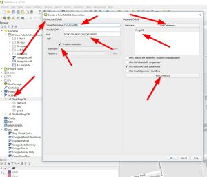
This Server was also running under Windows Authentication and worked fine. I had trouble with Knime connecting with Win Authentication, but no trouble at all with QGIS. 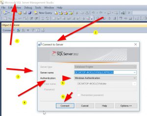
End comment
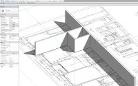
There is also the 3D Views that can be explored. I’m still trying to get my head around how the Z component is created to be able to do this.
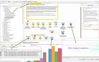
I thought this was a smart bit of mapping, calculating Catchment.
I’m pleased with the preliminary revisit to QGis, its definitely got faster and also importing/connecting to maps, other data sources seems easier.
I was a bit surprised how slow the rendering took for the map, although it is doing an awful lot of work. I like, in Revit, that you can send that to the cloud so that it does all that processing up there.
This video would be something I’d be interested in replicating, showing buildings in 3D. It would be good to only show selected ones that I was working with.
Another thing I’d like to explore with QGis is being able to share info I have created, similar to the Google Maps stuff I have worked on.So being able to post it to the web would be interesting. I need to research that. Maybe the next post.