3D models for visualisation in Google Earth & data attached to models

Google Earth allows you to place your 3D models onto the Earth.
(Prior to 2012 they allowed these models to be uploaded publicly but have since stopped that, so there are a number of 3D models inside Google Earth).
- Speed up the tedious stuff and enjoy designing and documentation more
- Works in all versions of Revit
- Information to PROVE your increased speed
From Revit you can export the model using the Free Lumion Collada Exporter. These can then be loaded into Google Earth.
(Limion Collada Exporter allows you to render the model into a .DAE file. You can go to File – Open in Google Earth, in the “File type” drop down list there is an option “COLLADA model file (*.dae)).
An example of this is the Google Earth fly through TOUR on YouTube here. Video (5.24 min):
The models are brought in and loaded into your Browser client side, so that you are running a version of Google Earth over the web but pulling the models from your server (or local KMZ file). So it is possible to compile a KMZ file that has a number of these Collada models and information in them and give that to others to load into their Google Earth setup, thereby allowing them to see the models on their device.
It it easy to load and setup the models into Google Earth, you have to nudge them to get them into the correct position.
The exercise I did was to use 3 complexes in Wellington. A cluster of apartments & stand alone houses on one site, A large 8 story apartment block and 5 buildings in the Civic Square. I deliberately chose larger buildings to see if they could process quickly in a browser.
Some of the challenges I had with this exercise:
- I needed to delete all the internal parts of the models and only use their shell, otherwise the models were too large.
- Some of the buildings geometry on larger files was a little fuzzy and odd (the 4 story apartment buildings in the multi use complex). The files would need to be broken down to fewer buildings in the file so that the quality of the models would improve.
- Colour. The models were in gray-scale, so do not look as good in the coloured Google Earth space.
- Existing conditions in Google Earth. For the mixed unit apartments and stand-alones the background in Earth was of an earlier development, so I had to put a slab under the buildings to conceal the earlier information.
- Pop up boxes on buildings was good to be able to give information on the buildings and also to have links to other files
- Measuring heights in Google Earth. The measurement tool only measures horizontal distances so you either have to use a Polygon or a Pin set to an altitude to get heights. A little convoluted but possible.
- The controls are not the easiest to use in Google Earth, but they will become easier to use with practice. I found a fast key (U- view in plan) helped me re-set when I got into trouble.
Visualising uses and issues
Some other work I have been doing, showing internal spaces using Revit Panorama renders allows for a 360 degree exploration of internal spaces from a specific point in the room. These are quite quick to set up and generate in Revit. These give you a clear understanding of each of the spaces inside the building.
Bathroom example of 360 view
Laundry example of 360 view
I then started to think of a method of exploring the outside of the building, and for the exercise I was doing above I tried using the walk through process in Revit, both externally and internally. Here is an example of a YouTube video (note- it goes fuzzy about 1/2 way through) :
I don’t like the walkthroughs as
- they are a video, so you go where the video takes you and
- it doesn’t have any relationship with the site or surrounds.
I think the Revit Exported DAE files into Google Earth give you a view of the outside of the buildings that you can explore in the same manner as you can in the Panoramas above. You can go around the outside of the building and look at it from different angles. A good use was for a contractor looking to paint the building to get a rough idea about how they intended to scaffold around the building and maintain egressways etc. or how one would go about repairing a specific window externally on a facade of a building.
For the new practice of sealing the building envelope in plastic to allow for work to take place regardless of weather conditions, I read an article where the contractor used a drone to inspect the building to see if their were any tricky issues on the roof or in places where he may not have had line of sight. This technique using models in Google Earth allow you to do this too.
Some final comments
The powerful thing is that you control the data, you send someone the KMZ file (the one holding all the models in the video above is 8MB in size).
I think this tool can be used for Facilities Managers who are managing a large number of buildings spread around in different locations. It allows a good overview of the buildings and their relationship to their site.
The current continuum from Design (90% graphical, 10% Data- through Construction 50% graphical , 50% data- to AM/FM 10% graphical & 90% data needs to be stretched at the AM/FM end to allow more graphical information. The examples above of getting a feel of the task in hand (external painting/ replacing a window, even moving plant off roofs) can better be planned and priced if the information is available at hand. In the age of BIM, architects spend a long time capturing data and translating it into a graphical manner that conveys so many issues that raw data cannot, that it seems a waste, in the current age, to throw that information away and only work with mostly raw data, especially when it is not too hard to keep that data available for use in easily available programmes that are accessible to the majority of people in the AM/FM area.
Multipurpose function hall and variable seating prices
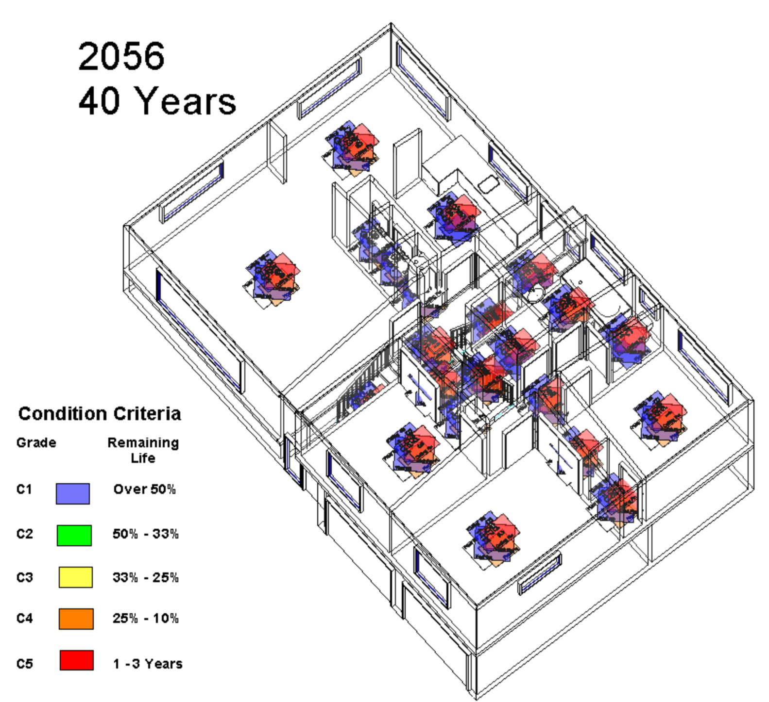
Revit Internal Condition over Time